FAMILY MEMOIRS
by Mike Spack
Part 1
...in collaboration with sisters Nellie Balayewlch and Margaret Eagle
DEDICATED TO OUR WONDERFUL AND SO VERY REMARKABLE MOTHER
PREAMBLE: This task of documenting one's family history is a monumental one. Certainly the cooperation of other family members namely sisters Margaret and Nellie and perhaps one or two others will be essential. Nevertheless this writer begins with the expectation that this is a challenge for a lengthy stint of writing, researching, and whatever it takes to complete this project. God willing. Additionally, the first writing will perhaps be a more detailed one In story form with lengthy personal memoirs after which a summary could be considered in order to provide a more sequential history of the family. The sorting out according to date has been and will be difficult. Indeed one may only seek the sympathy of the readers to make allowances for this. Finally. the Appendices I to V may be interesting to those who rely on more detailed background information.
How best to begin and how to assimilate the information from others? Questions to sisters will provide their experiences. Time will tell what seems to be the best approach. The stories begin knowing there will be many gaps which may or may not be filled from other sources of information. Also, I cannot vouch for the accuracy of facts and indeed there may appear to be a number of inconsistencies as well as some judgmental biases. Repetitions are inevitable but hopefully these are at a minimum. Various picture and maps are included and these are self-explanatory.POINT DOUGLAS . . . geographical And so it begins. . .
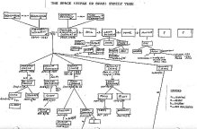
SPACK FAMILY TREE
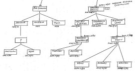
Click for full-sized view
A FAMILY HISTORY OF THE SPACKSA quick look is useful geographically at the local neighborhood north Point Douglas where we spent our pre-school and public school days. Public schools were Norquay to Grade eight location shown on rough map (see next pages), Aberdeen for Grade 9 on the other (west) side of Main Street and St. Johns Technical High School for Grades ten, eleven, and twelve further north on Salter (a long walk of approximately three to four miles from home Aberdeen and St. Johns High schools not shown on map).
By the way, defining the Point Douglas boundaries then and now is rather indefinite. The Plan of the City of Winnipeg 1876 and particularly the rough diagram of this peninsula Point Douglas (black line next page) is best oriented by locating on the rough plan of north Point Douglas (second map), the Disraeli Bridge. Louise Bridge, Sutherland Avenue, Euclid Avenue, Main Street, the railway track and alongside it Higgens Avenue which is in south Point Douglas since the railway splits Point Douglas north from south.
On the north side note how all the streets east of Main Street starting with Granville just east of Norquay School continuing east to Angus (a street I found on a Winnipeg map but one whose name I do not remember), are headed in a northerly direction to arrive dead end at Rover Avenue. Rover runs alongside the banks of the Red east/west dead end at Brown and Rutherford east and the cozy small Norquay Park west which for some reason was often referred to as "Banana" Park.
HISTORICAL
It is assumed based on seemingly credible information that these streets around 1812 were the sites of the plots laid out by the first Scottish settlers who arrived in 1812. These Scots came from the parish of Kildonan in Scotland hence this settlement was the beginning of the larger area named Kildonan which in turn, as settlement spread further north, was divided Into west, east, and north Klldonans. According to E.S. Russenholts book, 1968. titled "The Heart of the Continent", governance from 1812 to 1869 with some reorganization was handled by an appointed Council of Assiniboia first called into session by Lord Selkirks resident governor Miles Macdonnell.
Some historical Winnipeg events leading up to 1812 and beyond are noteworthy taken from the January 1, 1972 Winnipeg Tribune newspaper titled "Memories of Past Salute City of Future":
1736 ... French explorer and trader La Jemeraye at the Forks, junction Red and Assiniboine Rivers, which became a well known meeting place for travellers arriving from many localities plying the fur trade of course some of whom no doubt settled in the area. The name "The Forks" which today is a remarkable tourist and local attraction was used often in the past, this confluence of the Assiniboine and Red Rivers. Also, there is indication that this was the earlier site Fort Gibraltar.
1737 ... La Verendrye meets with the Indians
1738 ... De La Marque built Fort Rouge at the Forks.
Worth listing are the dates of events emanating out of the 1812 settlements.
1820 ... Hudsons Bay Company and the North-West Company are united after having had many a dispute in one case resulting in destroyed buildings in Point Douglas in or near 1812. However Scottish hardiness prevailed and rebuilding took place.
Result - almost a complete change including fine residences. Some well known affluent persons resided there such as John Norquay (Premier) and Jim Ashdown (merchant). Norquay School is of course named after John Norquay. Many prominent people especially from England had streets named after them in Point Douglas e.g. Granvllle, Hallet, Disraeli, Barber, and Gladstone to name a few.
1855 ... William Ross is appointed postmaster and the Ross House may be seen today. It is located in the small triangular Joe Zuken Park (an alderman of long standing in Winnipeg) in north Point Douglas on Meade street not far from Euclid. An article In the Winnipeg Free Press, March 4, 1990, by John Lyons states "the park likely has more history per square foot than any other section of Manitoba. Ross House is also one of the city's oldest homes ... notable for its historic plaques which commemorate the nearby planting of the first wheat in the region in 1812 as well as the earliest well." The 125 year old Barber House on Euclid Avenue partially renovated may be seen today located not far from Ross House. (see map)
1866 ... Winnipeg for many years was known as Fort Garry, a name first used on this date by the newspaper with Nor'Wester on its masthead . Winnipeg originates from the Cree word "Winnipy" meaning "murky water" (some say "muddy")
1867 ... British North America Act.
1870 ... Manitoba becomes a province.
1882 ... Horse drawn cars operated n Winnipeg.
1890 ... Winnipeg School District #1 inaugurated.
1892 ... First electric street cars operated.
Finally, from John Lyons' article Rostecki: " The railroad squelched things for Point Douglas as a "hoity-toity" neighborhood or anything above working class ..... noting the noise and smoke of the trains carried a negative stigma". Additionally, the agreement made presumably by the City Council with the "ladies of the first and longest profession" to move them from Minto to Anabella Street gave the area a stigma it carries almost to this day. The Red Light District as it was known combined with the depression times, bootlegging and "hot" stolen cars all contributed to its being known often as the "little Chicago" of Winnipeg. For most of our years of growing up we lived in little Chicago although in our youth days we were not really cognizant of this unsavory reputation but were were witnesses on many occasions often misunderstanding what this all meant.
|
|
|
|
|
|
|
|
|
|
|
|
|
||
|
|
|
|
|
|
|
|
|
Contact Daughter
Cathy at:
cspack@mymts.net
![]()
|
As You Were . . . Tribute Webzines |
Hillman WWII Tributes www.hillmanweb.com/war |
www.hillmanweb.com/rcaf RCN HMCS PRINCE ROBERT www.hillmanweb.com/rcn |
Ex-Air Gunners Association Magazines |
![]()
![]()
![]()
Webmaster:
William G. Hillman
BILL
& SUE-ON HILLMAN ECLECTIC STUDIO
Editor and Webmaster Bill Hillman
~ Copyright 1996-2021