Early activity in the area, that would eventually evolve into the Strathclair
district, was centred on the Little Saskatchewan River and its valley about
midway between Riding Mountain and the Assiniboine River (Figure 1) Area
Map. The Little Saskatchewan, a tightly- meandering tributary of the
Assiniboine, flows south out of Lake Audy and Clear Lake in what is now
Riding Mountain National Park (RMNP) and then follows a generally southeastward
course through a fertile, deeply-entrenched, heavily-treed valley. Members
of at least two early exploratory expeditions, those led by Dickinson and
Hind, recognized this valley as one of the best in the northwest in terms
of beauty and settlement potential.1 Along
with the deep fertile alluvial soils, the valley contained an abundance
of good water, wood, pasture and gravel deposits, as well as offering a
relatively easy transportation route for water cargo. It is where the river
turns southeast at 36-17-22 that the first settlement took form. The location
also gave the settlement its name -- The Bend (Figure 1) Area
Map.
The area north of The Bend was dotted with sloughs and lakes interspersed
with stands of poplar, spruce and birch. It eventually became the Riding
Mountain Timber Reserve (and then RMNP) and the Keeseekoowenin Indian Reserve
No. 61. The excellent hunting, trapping and fishing here was the raison
d'tre for the Hudson's Bay Company (HBC) Trading Post upstream near the
present site of Elphinstone.
The rolling hills and open grassland south of The Bend presented stark
contrast to the northern woodland. The unobstructed prevailing westerlies
fanned prairie fires in the summer and whipped up blizzards in the winter.
Indian tribes had long encouraged fire to enhance grassland for buffalo
grazing and, indeed, an early settler, Lord Elphinstone, found that these
grazing grounds lent themselves to successful ranching enterprises.2
Wood for fuel and buildings had to be hauled from the river valley or from
farther north, but as soon as the land was broken, bluffs of poplars took
root and spread out from the low-lying potholes or sloughs.
Several settlements sprang up before the arrival of the railway. About
10 miles south of The Bend and just east of the southern tip of Salt Lake
was Old Marney (2-16-22) which, at one time, boasted a store and post office,
a blacksmith shop, a brickyard and the Do-Drop-Inn Hotel. Farther east
was the Forks (33-15-21), a junction at which the Carlton Trail (known
also as the Hudson Bay Trail or Ellice Trail) continued on its westerly
route to Fort Ellice on the upper Assiniboine while a branch broke off
northward to The Bend. From there it followed the river to Lake Audy and
continued north to Gilbert Plains, Fort Dauphin and the Swan River Valley.
Many settlers travelling to the north took this Strathclair-Dauphin Colonization
Trail (Figure 1) Area
Map, a route which followed an established Indian trail from the buffalo
plains along the east side of Riding Mountain on a Lake Agassiz beach ridge.
They found this route to offer the firmest ground, easiest grades, and
the driest sites for camping.
So, the nuclei and the pattern for farm settlement were determined before
the railway arrived -- The Bend, Riding Mountain HBC Post, Old Marney and
The Forks were connected by the river, cart routes and Indian trails. By
the mid-seventies the area had been surveyed by Duncan Sinclair and a section-township-range
grid was in place for future homesteaders and settlement. Wagon loads of
adventurous Scots from the east began to arrive having travelled by rail
to Winnipeg. Scottish place names soon appeared; for example, Menzie and
Glenforsa. Even The Bend was renamed Strathclair, a combination of the
Scottish word "strath" for valley and "clair" from the surveyor, Sinclair's,
name. Then came the Manitoba and North Western Railway (now a branch of
the Canadian Pacific Railway), which traversed the area midway between
The Bend (Old Strathclair) and Old Marney (Figure 1) Area
Map. Before the end of the century the original four settlements --
The Bend (Old Strathclair), Old Marney, The Forks, and The Riding Mountain
HBC Post -- had shrivelled and most activity had moved to the upstart Strathclair
Station located in 35-16-22.
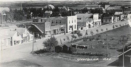
This event had a profound effect on the development of the area. Besides
the obvious adjustments to the technological and cultural changes brought
by the railway, pioneers had to erect a town from scratch on a barren prairie.
Furthermore, because the railway company held rights to the land along
the line, the town's business strip stretched along only the northeast
side of the main street, which ran parallel to the tracks in a northwest-southeast
direction, a situation characteristic of many prairie towns (Figure 2)
Aerial
Photo.
Pioneers such as James Campbell who had settled some distance from 'civilization'
(NW 24-16-22) now found themselves on the fringes of a booming settlement
with full rail services.3 The railway and
land companies carried on extensive advertising campaigns to lure new settlers,
resulting in a flood of newcomers, and infusion into the area of a much
more diverse ethnic mixture. By 1888, even the Premier of Manitoba, the
Honourable John Norquay, had a summer home on the north east corner of
Salt Lake -- a lake which was fast becoming a popular picnic and resort
spot. He had plans to erect a sanitorium there, as analysis of the waters
had shown them to be beneficial to sufferers of rheumatism. Unfortunately,
these plans never materialized as he died suddenly. Nevertheless, by the
turn of the century, Strathclair had grown into a robust and thriving farm
community.
Strathclair in the '50s
The glory years of Strathclair and many other similar prairie communities
reached their zenith in mid-twentieth century -- the '50s decade. The excitement
and spirit generated by these towns was perhaps best epitomized by the
Saturday Night "event." Following the Saturday evening supper hour, families
would prepare to "go to town." The first cars to arrive would get the best
seats. This meant finding a diagonal parking spot along the north side
of main street (North Railway Street) in the well-lit, high-traffic area
extending from the pool room at Minnedosa Street to the modern 'self-serve'
department store at Campbell Street (Figure 3) '50s
Town Map. Between these termini, people of all ages walked a jostling
gauntlet along a strip of thriving businesses. Three favourite spots were
the drugstore with its soda fountain and magazine rack, the Chinese cafe
with its booths for socializing, and a rival eatery which featured a jukebox,
pinball machine and lunch counter with stools. Many of the men gathered
in one of the two male bastions -- the beer parlour and the pool room;
while a favourite routine for the women was to peruse the line of parked
Fords, Chevies and Dodges -- each vehicle demanding a nod, wave or a detour
off the sidewalk for a chat. When the week's discussion lagged out on the
street, there seemed to be no end of open doors to shops to provide diversion:
bakery, grocery, dry goods store, newspaper office, garages, butcher shop,
hardware store, restroom, shoemaker, and tinsmith. In the winter there
was always skating, curling and hockey at the rink. The routine for some
was to go to the 7 o'clock movie at the Bend Theatre, delaying the sidewalk
promenade for later. From a thirty-five cent allowance, kids could eke
out a full night's entertainment which included a movie (complete with
newsreel, Three Stooges short, cartoon, serial, previews, and draws for
prizes), popcorn, "coke" or popsicle, double bubble gum, jawbreakers, and
a fifty-two page comic book. Later in the decade, many people gathered
outside the electric shop which provided an outdoor speaker connected to
the twenty-one inch television in the window, few realizing that this box
with its flickering black and white pictures was a harbinger of drastic
change to this weekly social phenonemon that everyone took for granted.5
Just as the inception and growth of Strathclair were typical of many Manitoba
towns, so too were the changes the town and surrounding district experienced
throughout the twentieth century. While agricultural service centres have
waned, the surrounding farms have become larger without a corresponding
increase in total area farmed, resulting in fewer farms and decreased population.
Increased capitalization, mechanization and the use of chemicals have resulted
in farming becoming more of a competitive industry than a way of life.
Money which once went to the maintenance of a labour force and working
animals now is diverted to high tech machines, devices and chemicals. The
fields are larger with different things in them -- less summer fallow,
more trash cover, and a greater variety of crops. To facilitate the use
of large machines many of the sloughs have been filled in; stone piles
buried; road allowances and section lines worked; traditional early twentieth
century-style barns, outhouses and granaries torn down; and bluffs and
old farmsteads bulldozed. Some of the items removed have been replaced
by windward-located, Prairie Farm Rehabilitation Administration-supplied
shelter belts, utilitarian steel structures, and mobile homes or ranch-style
bungalows. The transportation grid serving these re-organized farms consists
of wider, higher roads designed to handle the winter snow pile up, spring
runoff water, and larger, heavier machines and vehicles.
Most farm service towns have experienced a steady decline over the last
half of this century and Strathclair is no exception. Despite some lack
of foresight, occasional political blundering, and the fluctuating economic,
social and geographic climate, pragmatic changes in role emphasis have
brought about some degree of success in the ongoing fight for survival.
In addition, as districts such as Strathclair enter the Computer/Communication
Age it becomes increasingly obvious that they will survive only if they
can adapt to the challenge of the new technologies and integrate them with
the agricultural base.
Throughout their history and evolution, the successes and character of
communities such as Strathclair have come largely from their ability to
draw lifeblood from communication links -- foot and horse trails, fur trade
and supply routes, river travel, oxcart trails, rail lines and later, highways
with their bus routes and transport lines. Even the road grid laid out
on the section- township-range survey system seemed to exist to channel
farm trade into the local towns.6
Now, with most of these traditional lifelines either gone or rerouted to
bypass the local settlements, many towns seem to have lost the ability
to communicate with the outside. Today's links to the world have changed:
fibre optics and cable lines, cellular telephones, computer networks, faxes,
satellite communications, and high-speed land and air travel are now the
norm. Highway traffic can be lured by roadside way stations but such traffic
has little inclination or incentive to drive through every little town
en route. Those towns and agribusinesses unwilling to embrace the new technologies
which facilitate access to modern-day communications, will most certainly
be passed by. Strathclair, progeny of the interplay of traditional trails
of the past, now faces the complex task of tapping the uncharted myriad
trails leading to the strange new frontier of the twenty-first century.7
End Notes
1 H. Y. Hind, Report of the Assiniboine and Saskatchewan Exploring Expedition
(Toronto: John Lovell, by Order of the Legislative Assembly, 1859)
2 Lord Elphinstone, "Visit to Western Canada 1979" The Edmonton Courant,
13 January 1880.
3 K. Campbell, The Journals of Katherine Campbell: 1933-1971 (Strathclair:
Maple Grove Publishing, 1991)
4 Strathclair Centennial History Committee, Our Story to 1984 (Strathclair:
Rural Municipality of Strathclair, 1984)
5 W. Hillman, Bill & Sue-On Hillman: A Prairie Saga in 24 Original
Songs (Strathclair: Maple Grove Records, Compact Disc Album, vol 10, 1993)
6 J. L. Tyman, By Section Township Range (Brandon: Assiniboine Historical
Society, 1972)
7 W. Hillman, "The Integration of Microcomputers with the
High School Language Arts Programme" (M.Ed. Thesis, Brandon University,
1991)
|